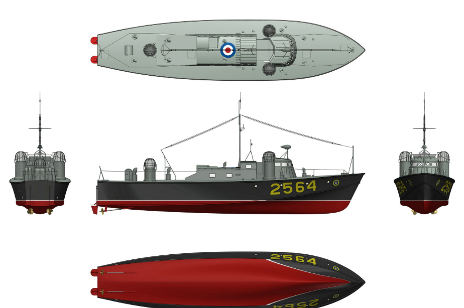
Introduction and intelligence of maritime patrol ship
Regarding the identification of ships, in the late last century, the United States, Japan and Western European countries developed the intelligent transportation system (ITS), which has now matured, pointing out the direction for the development of this field. Vessel traffic service system (VTS) was first established in Europe, initially used in inland waters, and has been widely used in coastal countries.
For maritime patrol ships, its main law enforcement objects include both large ships that are forced to install AIS systems, and small ships in relevant waters. Based on the relevant situation, this paper mainly puts forward two identification methods based on VTS+AIS mode (Ship traffic management system automatic identification system) and GPS+GIS+GPRS/CDMA system.
The VTS is an electronic system that displays the position, speed, and direction of a ship on the display through the front-end radar and the back-end integrated information processing system to realize traffic flow organization and navigation assistance. The advantages of this combination
It can maximize the complementary role of radar and radar, and basically achieve full coverage for large (and other ships that require mandatory installation of terminal equipment). However, the cost of shipborne equipment is relatively high, so the cost of installation is too large, and small ships such as sand and gravel carriers are non-ships, there is no mandatory installation terminal requirements, therefore, this program is not easy to promote the implementation of small ships.
GPS+GIS+GPRS/CDMA system positioning accuracy is relatively high, the resolution can reach 15 meters, the speed measurement accuracy can reach 0.1 meters second; It can more accurately grasp the surrounding information, mark the ship's position information on the chart through the map, realize the monitoring and management of the ship, and provide navigational assistance services for the safe navigation of ships in areas with high coverage of mobile and unicom networks such as coastal and inland rivers. It is more conducive to real-time communication. Within the coverage of mobile and Unicom networks, the network transmission speed is faster and the transmission accuracy is higher, which also achieves the goal of network communication. Economical and practical, cost-effective, which is also the biggest advantage compared with other ship monitoring methods. Some small construction ships, forcing them to install expensive equipment, will bring great economic pressure on these ships. The based scheme can make full use of the public communication service network, the network communication cost is low, the cost of shipboard terminal is lower, and it will not increase the economic burden of the ship like the equipment, which is more conducive to promotion.
Because the data format of GPS information and AIS information can be converted by technical means, the data information of the boat can be integrated in the system.
2. Safe and autonomous navigation
The navigation of intelligent ship puts forward high requirements for the safety of communication and the reliability of equipment. For communication, generally speaking, a complete security model should be composed of the following five parts: security management, intrusion detection, security protection, security recovery, security response. The evaluation of the degree of network security should follow the "wooden barrel principle", that is, the lowest degree of network security as the basis for judgment. Therefore, a secure and leak-free system should strengthen network security from all aspects, and a multi-layer security protection network should be built. In the realization of positioning function and data transmission, the GPS positioning system with stable signal and low cost is selected, as well as GPRS network system, highlighting the idea of saving funds; In the application of small boat monitoring system to management, through the study of the new system, we find a way to integrate the small boat AIS target into the target, which caters to the trend of system integration. In the aspect of network architecture, the VTS security network is carefully analyzed and studied, and a four-layer security architecture is proposed, which embodies the concept of network security.
The automatic navigation of intelligent ship needs a series of hardware and software support, the existing one-person bridge and unmanned engine room technology is not stable, usually can not play a due role in the practice process. In the algorithm design of intelligent ship, variable theory domain fuzzy control should be adopted to realize the precise control of ship heading by controlling the rudder Angle output in real time. At present, expert system, fuzzy control, neural network and other control algorithms as the core of the fourth generation autopilot system. At present, the common ship course control system is mainly composed of host computer, course controller, rudder servo system, etc. The host computer is the sending end of data parameters, which mainly realizes the setting of course control value and the input of the current ship disturbance. The course controller realizes the output of rudder Angle by intelligent algorithm based on the relevant data. Finally, the rudder servo system realizes the steering gear control and the current rudder Angle feedback, so as to realize the ship course intelligent control.
- EMERSON
- Honeywell
- CTI
- Rolls-Royce
- General Electric
- Woodward
- Yaskawa
- xYCOM
- Motorola
- Siemens
- Rockwell
- ABB
- B&R
- HIMA
- Construction site
- electricity
- Automobile market
- PLC
- DCS
- Motor drivers
- VSD
- Implications
- cement
- CO2
- CEM
- methane
- Artificial intelligence
- Titanic
- Solar energy
- Hydrogen fuel cell
- Hydrogen and fuel cells
- Hydrogen and oxygen fuel cells
- tyre
- Chemical fiber
- dynamo
- corpuscle
- Pulp and paper
- printing
- fossil
- FANUC
- Food and beverage
- Life science
- Sewage treatment
- Personal care
- electricity
- boats
- infrastructure
- Automobile industry
- metallurgy
- Nuclear power generation
- Geothermal power generation
- Water and wastewater
- Infrastructure construction
- Mine hazard
- steel
- papermaking
- Natural gas industry
- Infrastructure construction
- Power and energy
- Rubber and plastic
- Renewable energy
- pharmacy
- mining
- Plastic industry
- Schneider
- Kongsberg
- NI
- Wind energy
- International petroleum
- International new energy network
- gas
- WATLOW
- ProSoft
- SEW
- wind
- ADVANCED
- Reliance
- YOKOGAWA
- TRICONEX
- FOXBORO
- METSO
- MAN
- Advantest
- ADVANCED
- ALSTOM
- Control Wave
- AB
- AMAT
- STUDER
- KONGSBERG
- MOTOROLA
- DANAHER MOTION
- Bently
- Galil
- EATON
- MOLEX
- Triconex
- DEIF
- B&W
- ZYGO
- Aerotech
- DANFOSS
- KOLLMORGEN
- Beijer
- Endress+Hauser
- MOOG
- KB
- Moxa
- Rexroth
- YAMAHA
- Johnson
- Westinghouse
- WAGO
- TOSHIBA
- TEKTRONIX


Email:wang@kongjiangauto.com

